I walked across the Hamilton Avenue Footbridge from Red Hook, Brooklyn, to Carroll Gardens, Brooklyn, on May 4, 2022. I had only crossed the bridge two or three times previously. Having posted an article chronicling my trip across the nearby Summit Street Bridge in June 2021, I decided to photograph my journey across the Hamilton Avenue Footbridge for a new New York City bridge post.
Introduction to the Hamilton Avenue Footbridge
In my June 2021 post on the Summit Street Bridge, I explained why the Summit Street Bridge was necessary:
Thanks to the great violence that was done to Hicks Street in Carroll Gardens in the 1940s and 1950s, the Summit Street Bridge is needed to cross over the BQE from one side of Hicks Street to the other. To be clear – it is a bridge over the BQE from Summit and Hicks Streets In Carroll Gardens to Summit and Hicks Streets in the Waterfront District.
As I explained in that article, the BQE severed Columbia Street Waterfront District from Carroll Gardens and Cobble Hill. However, Columbia Street Waterfront District is a relatively small, narrow neighborhood. The most significant casualty of the Brooklyn-Queens Expressway (“BQE”) was the border between Carroll Gardens and the comparatively large neighborhood of Red Hook, Brooklyn. The BQE and its extension, the Gowanus Expressway, bisect Hamilton Avenue, which runs between the northern border of Red Hook and the southern border of Carroll Gardens. This resulted in Red Hook being one of Brooklyn’s more isolated neighborhoods. The purpose of the the Hamilton Avenue Footbridge is to provide an additional path between Red Hook and Carroll Gardens, although some locals have complained that the path is not the most inviting.
Hamilton Avenue has made two cameo appearances at The New Leaf Journal. I posted a short article about a desk that had been left outside on the sidewalk on the Carroll Garden-half of Hamilton Avenue back in 2020. You can see where Hamilton Avenue is cut off in the background of the photo. I covered a quainter Hamilton Avenue scene of a bench in 2021.
The Hamilton Avenue Footbridge on a Map
The following image of the Hamilton Avenue Footbridge on a map comes courtesy of Open Street Maps:
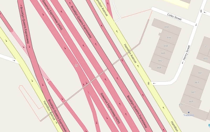
You can see a broader picture, along with a marker denoting my starting point, by following this link.
The map highlights that the Hamilton Avenue Footbridge does not exclusively pass over or under the highly traveled BQE and Gowanus Expressway. The small pedestrian bridge runs under the BQE and over the Gowanus Expressway, effectively weaving a narrow path for pedestrians from one neighborhood to the other. One Brooklyn Eagle reporter aptly described the trek as “a stroll beneath a highway.”
Chronicling My Journey Across the Hamilton Avenue Footbridge
On May 4, 2022, I walked across the Hamilton Avenue Footbridge from Red Hook to Carroll Gardens. Thus, I entered the Bridge at Hamilton Avenue and Luquer Streets in Red Hook and exited on Coles Street between Hicks and Henry Streets in Carroll Gardens. Last year, I wrote a post about a downed Dead End sign at the Coles Street entrance/exit of the Bridge, so you can see some earlier photos of what would be my final destination on my May 4, 2022 trip.
I took all of the photos in this article with the Open Camera App on my Teracube 2e phone. I will present the photos in this article in the order I took them in order to give readers an idea of what walking across the relatively lightly-traveled pedestrian bridge is like.
Approaching the Hamilton Avenue Footbridge
The Red Hook entrance to the Hamilton Avenue Footbridge is found at the intersection of Hamilton Avenue and Luquer. Do note that the half of Hamilton Avenue that you will see is on the opposite side of the BQE/Gowanus Expressway from my 2020 article about a desk on Hamilton Avenue.

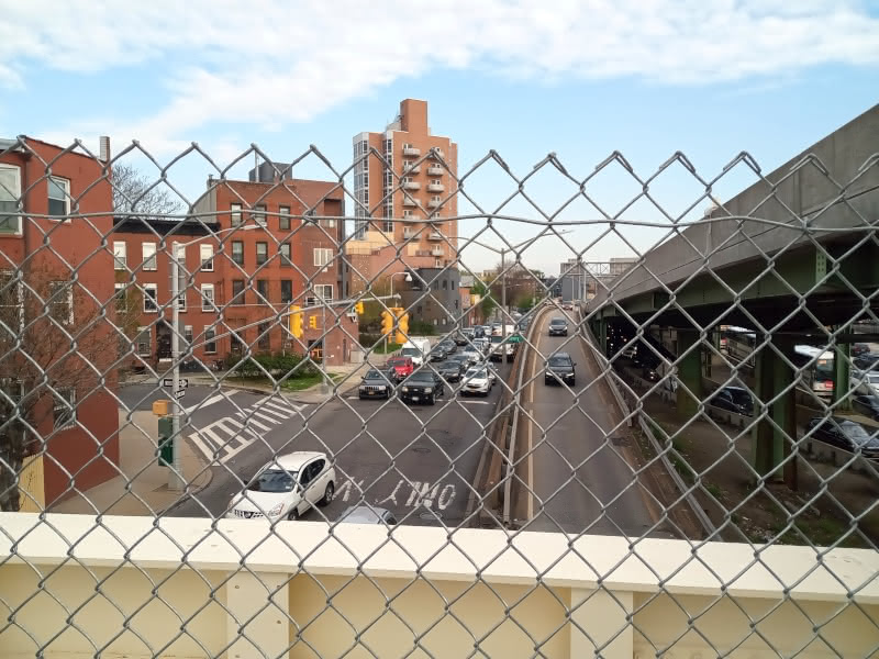
Before I stepped on the Bridge, I photographed its span from Red Hook.
Contrast with my similar photo of the span of the nearby Summit Street Bridge.
Note the tall building on the right side of the image – with its top cut off by the bridge. I wrote about a photo of that building from Carroll Gardens in a 2020 post.
Starting the Bridge
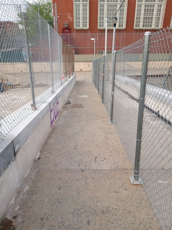
The Red Hook side of the Hamilton Avenue Footbridge begins with a small ramp. I dare say that this is the nicest section of our peculiar bridge.
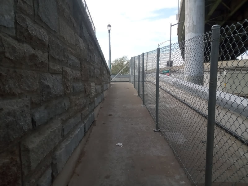
In 2020, I covered the Manhattan Bridge’s similarly pleasant start from the Manhattan entrance (see higher quality photo).
Before I turned the corner, I took a photograph of the next section of the bridge.

We then turned the corner to the second section of the crossing.
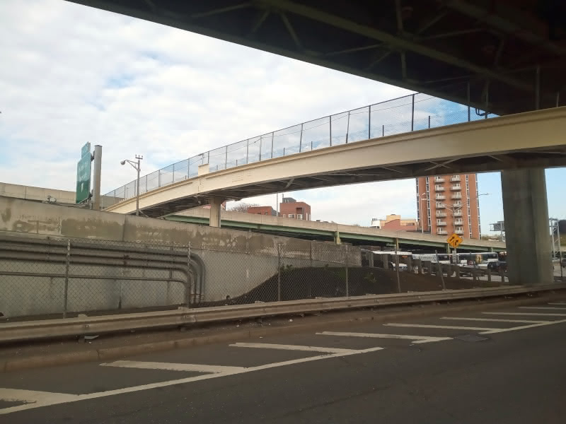
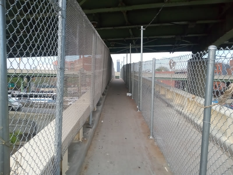
With the next turn, we begin our trip on an elevated path that runs under the BQE.
The View From Under the BQE
At the next junction we stare down the longest span of the Hamilton Avenue Footbridge in the shadow of the BQE.
I thought this spot presented a good place to show the view from the bridge. After a bike that was not supposed to be on the walkway passed me by, I took two photos. First, I look in the direction of Red Hook and, off in the distance, Manhattan.
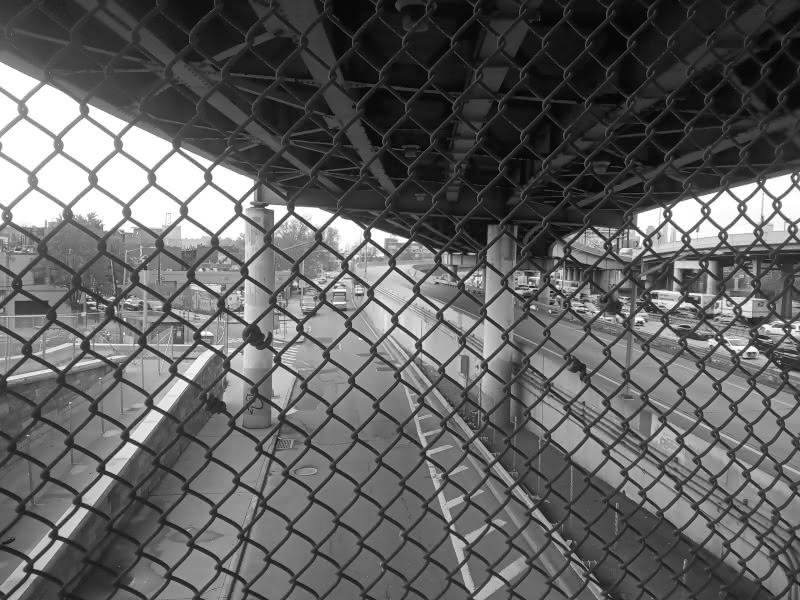
I made this photo black and white because the color version did not come out well. You can see the peaks of the Manhattan skyline, including the Freedom Tower, in the right corner of the photo. Do note (for those unfamiliar with New York City’s geography) that we are still separated from Manhattan by the East River.
Next, I turned to capture the view facing Brooklyn.
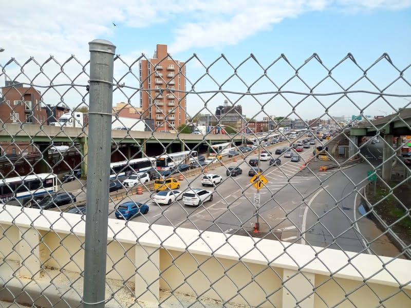
The road below me is the Gowanus Expressway. Note the tallest building in this photo in the left center. I wrote an article featuring that building all the way back in 2020, albeit my photo in that post captured the other side of the building from Carroll Gardens.
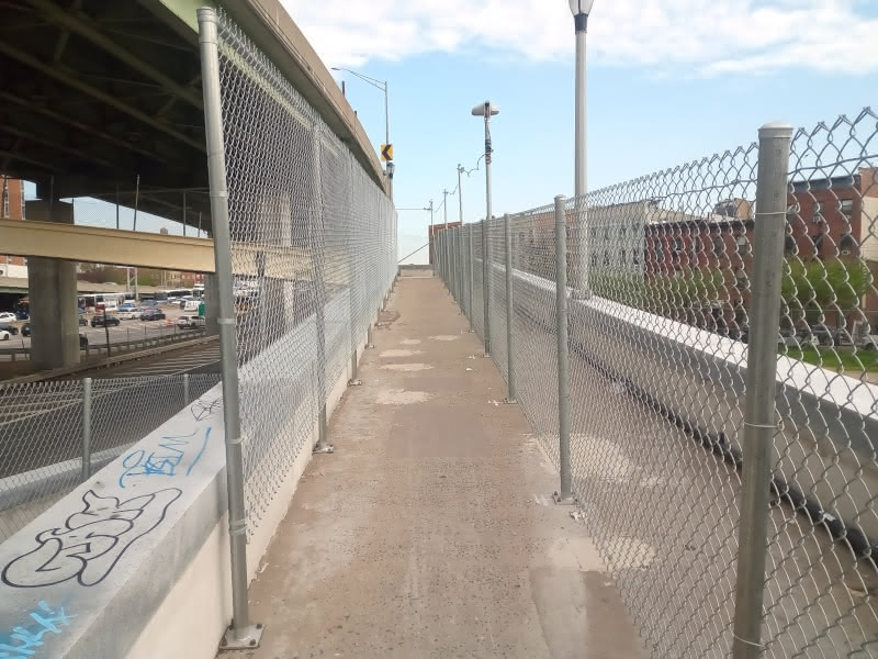
Continuing Down the Main Span
After I took my scenery photos, I continued from under the first BQE overpass to the middle of the Footbridge’s main span.
I then found myself under the BQE for the second and final time.

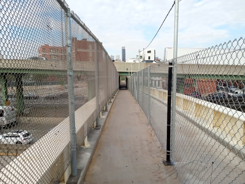
Before I embarked on the final descent into Carroll Gardens, I captured a scenery shot of the Hamilton Avenue side of the neighborhood.
Things are starting to look a little bit more scenic. Now, note the tall building that I singled out in the previous section of my trip. You can make out a small grassy patch in front of it. That is the location of the bench that I featured in a 2021 article.
Into Carroll Gardens
I began the final descent off the Hamilton Avenue Footbridge.
The large building in the background of the photo is Public School K146. I wonder how many students use the Hamilton Avenue Footbridge to commute. I am inclined to guess that not too many do in light of the fact that the walkway never seems to be heavily trafficked.
I reached the end of the Footbridge on Coles Street. The fallen Dead End sign that I captured from the opposite direction is no longer present. But the view into Carroll Gardens is quite pleasant.
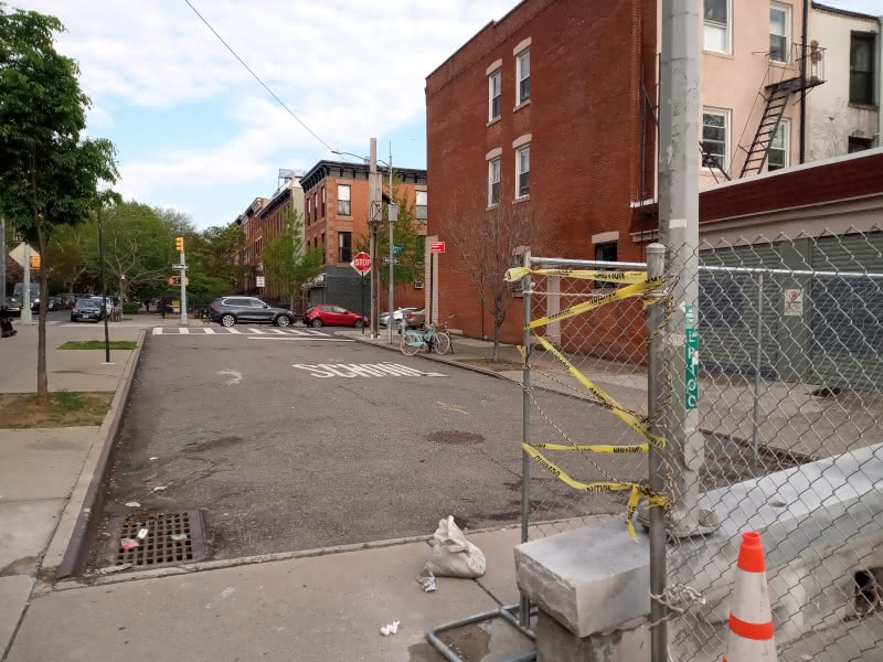
It is a distinctly different view than the Luquer Street entry/exit to the Bridge.
Before I continued on my walk, I turned around to photograph the Coles Street entrance.
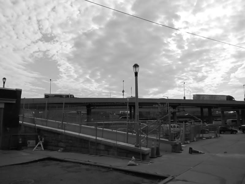
I decided to make the photograph black and white because the color version was a bit dark. This photo is also too dark – but it presents a nice contrast.
With that, my trip across the Hamilton Avenue Footbridge was complete.
Hamilton Avenue Footbridge Review
The Hamilton Avenue Footbridge is not the most aesthetic bridge in New York City. In that respect, it pales in comparison to the Summit Street Bridge, which is about 5 minutes’ walk from the Coles Street exit.
The sanitation conditions on the Hamilton Avenue Footbridge were acceptable. There were a few instances of graffiti, but they could have been worse. You will note some trash in the photos – but the Bridge was not too bad probably due in large part to the fact that not too many people use it. I was pleasantly surprised to find no dog mess on the walkway.
The great scourge of pedestrians in New York City are bikes. I did come across one electric bike on the walkway, which equaled the number of pedestrians. To be clear – the Hamilton Avenue Footbridge is a narrow walkway. It does not have a bike path. It is not at all amenable to bikes. Fortunately, the biker was riding slowly, so an accident was avoided even though he appeared in my line of sight only as I made the turn onto the walkway’s main span.
Some pedestrians may find the Footbridge a bit claustrophobic. The walkway is very narrow at all points, and the BQE runs quite low above the two sections where path runs below. There is fencing between the main span and the Gowanus Expressway below – something that cannot be said for some sections of the Triborough Bridge – but those who are averse to heights may find something unpalatable about the middle of the Footbridge.
The Carroll Garden approach to the Hamilton Avenue Footbridge is quite nice, running through the neighborhood’s brownstone-lined residential areas. The Red Hook approach is noisy (as a result of the looming expressways, of course) and not residential, but there are a few automotive workshops along the way. One interesting point is that both entrances to the Footbridge are innocuous and easy to miss. One could easily walk right by the entrance in Carroll Gardens without seeing it, much less having a clear and distinct idea where the Footbridge leads. The entrance is even more out of the way on the Red Hook side – the initial path on Hamilton and Luquer is only visible on the side of the sidewalk adjacent tp the BQE.
The Footbridge is not the only place that one can cross between Carroll Gardens and Red Hook. There is a relatively safe crossing at Hicks Street (albeit one could debate whether that crossing is Carroll Gardens or Columbia Street Waterfront District), closer to where I met an L-shaped desk in 2020. There are less safe crossings under the BQE in the opposite direction at Clinton and Court Streets.
My usual path to Red Hook is through Columbia Street Waterfront District instead of Carroll Gardens or Gowanus. In most cases, I think that the Footbridge would be more useful for people crossing from Red Hook to Carroll Gardens than from Carroll Gardens to Red Hook.
The Footbridge is not the prettiest bridge, but it is an interesting one in terms of its structure and also its being relatively out of the way. Given the paucity of easy links between Carroll Gardens and Red Hook, it serves a purpose for some commuters – even if its purpose is a bit niche.